This series of pages describes some of the thoughts/events that surround the construction of our workshop/lab/house in Shenandoah, Virginia including a series of images that show (chronologically in most cases) the progress of various stages of the construction. I hope you all enjoy!
Last update April 20th, 2009 adding text and pictures to Part 3 and adding the conclusion.
View from the air with GIS boundaries This will give you some idea of the boundaries of the property.
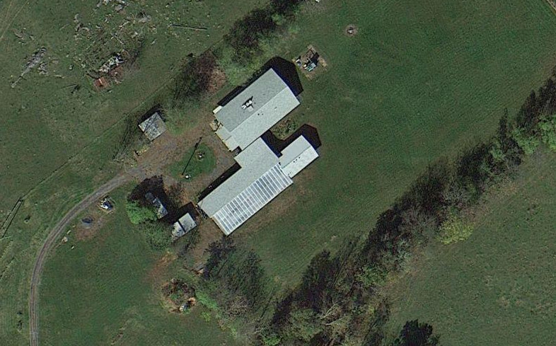
An overhead image showing the driveway, house, etc. taken the winter of 2006/2007
the Plat showing the approximate layout of the driveway, house, etc.
Getting Started picturs of our driveway and the area just before we started construction.
Part 1: Ground break to (mostly) dried in, March - August 2006.
Part 2: Interior walls, rough-in inspection and insulation, Sept 2006 - Dec 2007.
Part 3: Drywall, cabinets and sundry finsh work. Jan 2008 - Spring 2009
Concluding thoughts.
On July 4th, 2009 we had a party and took some pictures.
Begining mid July 2010 we started to build wooden patios along the length of the house.
Starting April of 2011 we are constructing a greenhouse / pool. You can find some images from our architect and plans (and ideally pictures of the on-going work) here.
In addition to the backhoe we purchased from our friend Wade in Spring of 2011, we also purchased a skid steer.
Click on image to go to Google Maps. Below are directions from the Northern Virginia area.

The address is 463 Quicksburg Road, Quicksburg, VA 22847, otherwise known as lots 2 and 3 of Pinehills Subdivision.
Directions from DC area:
- Take Interstate 66 West to Interstate 81 South.
- Exit at Mount Jackson (mile marker 273).
- Turn right at the end of the ramp onto Mt. Jackson Road (you are about 7 miles away), drive about 1.4 miles.
- Turn left at the next stop sign onto South Middle Road, drive a total of about 5.2 miles.
- Proceed through the next stop sign (cross over Orkney Grade, Route 263).
- Turn left onto Quicksburg Road (you are about a half-mile away at this point).
- Drive down the hill, cross the creek and look for the driveway on the left as the road turns to the left. The driveway is across from Apple Tree Lane. If you reach Pinewoods road to the left you went too far.
- The driveway is about 1/3 of a mile long and the house can't be seen from the road during the summer, so just keep on keepin on.
Directions from points South (Harrisonburg, Charlottesville, etc.):
- Take I81 North to exit 257, Broadway / Timberville.
- Turn LEFT at the end of the ramp onto Rt 11 South.
- Cross over I81 and turn right at the light onto Rt 259, Mayland Road, drive a total of about 12.4 miles.
- After about 4.4 miles Rt 259 turns into Rt 42, but keep straight through Timberville.
- You will hit a stop sign in Forestville, turn right onto Quicksburg Rd, Rt 767, at this point you are about a half mile away.
- Drive down the hill, cross the creek and look for the driveway on the left as the road turns to the left. The driveway is across from App
le Tree Lane. If you reach Pinewoods road to the left you went too far.
- The driveway is about 1/3 of a mile long and the house can't be seen from the road during the summer, so just keep on keepin on.
For other routes, give us a call.
NOTE: VERY IMPORTANT!!!
For some reason lots of maping functions have the location of our house wrong and have us further down Quicksburg Road. It also seems that many GPS will route you using a different exit (often the Shenandoah Caverns exit) which will take you through some pretty back roads, but can get you completely lost. Cell recetion around our house is very spotty (and almost absent at our house!). PLEASE keep this in mind if you decide to visit!!!!
Here is a link to the Shenandoah GIS web site: http://www.shenandoahgis.org/
MSN map link.

